
The Forts of Mose
Two forts, one marsh island: how the fort at Mose changed from 1738 to 1763
Two forts, one site
Fort Mose was not a single fort but two, built fourteen years apart on the same small island in the salt marsh about two miles north of St. Augustine. The first was built in 1738 and destroyed in 1740; the second was built in 1752 and stood until the cession of Florida to Britain in 1763. Both stood on the bank of a tidal creek — now Robinson Creek — that connected the island to the city, and both were anchored to the marsh itself as much as to their own construction.(1)
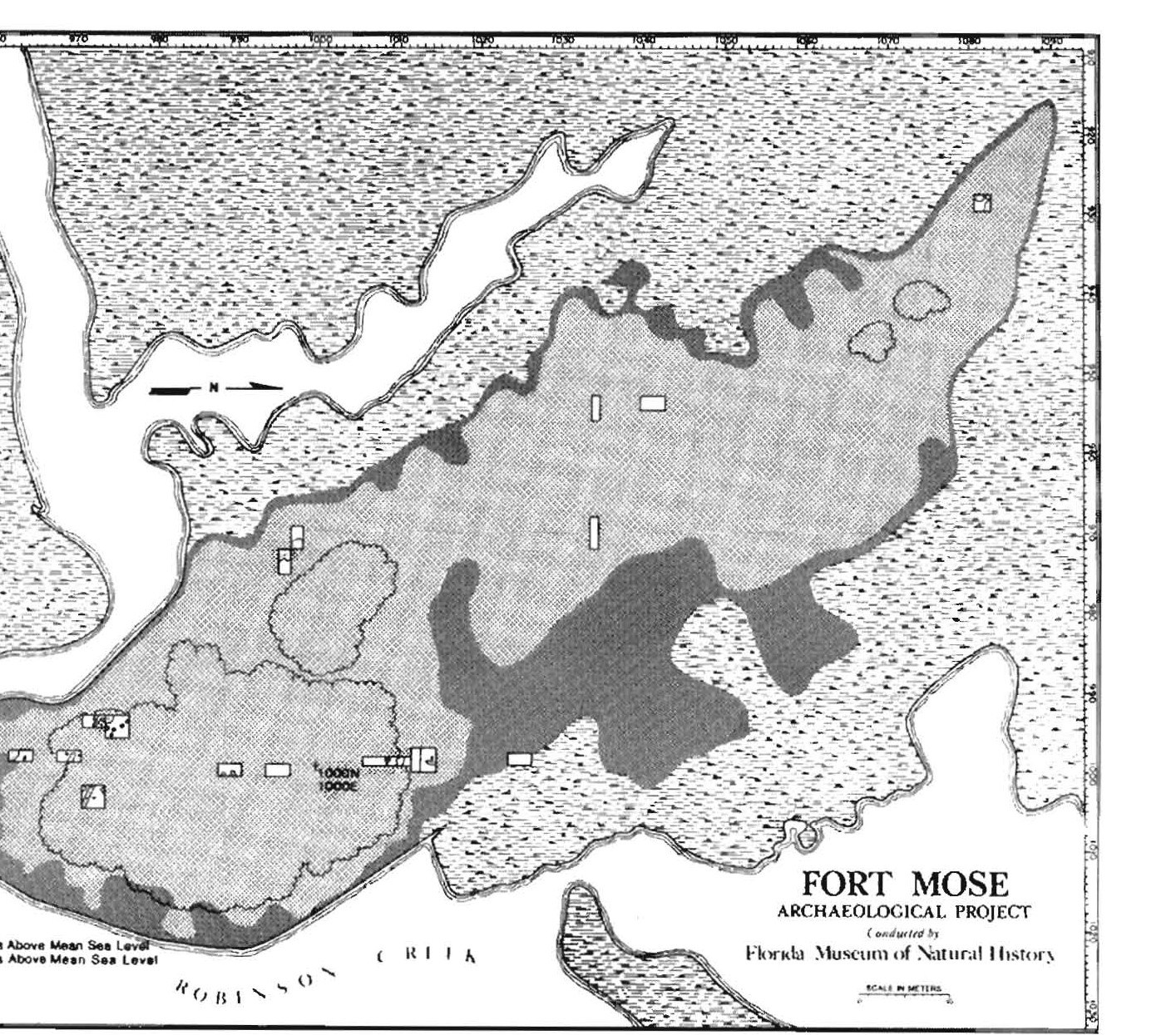
Where exactly the forts stood was long a matter of inference from maps and documents. In 1987 and 1988, a team led by Florida Museum of Natural History archaeologist Kathleen Deagan excavated the site and verified it beyond doubt as the second fort. Remote sensing — thermal imagery taken from an aircraft — then located the first fort, which today lies underwater in the marsh, and confirmed that the excavated island was the second.(2)
The first fort (1738)
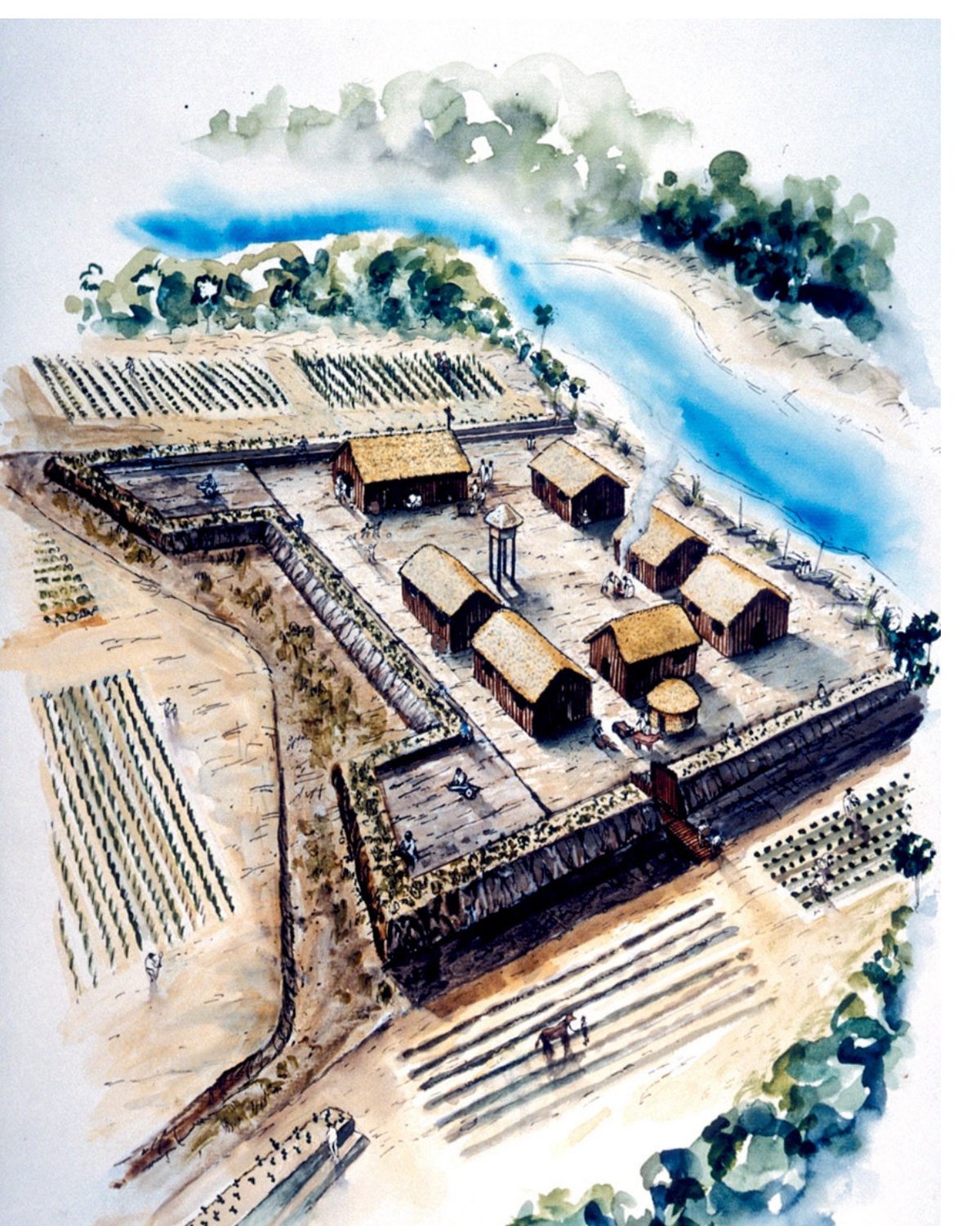
The first fort was small. It was a square earth-berm structure with a flanker at each corner — a small projecting work at each angle that let the garrison fire down the face of the adjacent wall. The earth walls were surrounded on all sides by a moat filled with cactus (opuntia), the prickly-pear that made the approach painful. Inside the walls stood at least one large house, a lookout tower, and a well. Documents indicate that some part of the structures may have been built of stone, but the primary material was wood.(3)
The British, who took the fort in 1740, described it in their own words: it was “built of stone, four square with a flanker at each corner, banked with earth, having a ditch without on all sides lined round with prickly royal and had a well and house within, and a look-out.”(4) The layout was similar to other small Spanish Florida forts of the period — a compact, defensible square meant to hold a small garrison and command the approach from the north.(5)
Thirty-eight men, most of them married, lived at the fort with their families. They were expected to farm the nearby fields and to man the defenses. The fort was built in 1738 or 1739, shortly after Governor Montiano established the town of Gracia Real de Santa Teresa de Mose for the freedmen.(6)
The twelve years (1740–1752)
The first fort existed for less than two years. In 1740, when General James Oglethorpe of Georgia marched on St. Augustine, the Spaniards evacuated the people of Mose to the safety of the Castillo de San Marcos. One of Oglethorpe’s officers, Colonel John Palmer, occupied the fort for the British. Oglethorpe ordered the gates burnt and three breaches made in the walls. When the Spanish garrison — including the free Black soldiers of Mose — counterattacked and routed Palmer, they destroyed what was left of the fort.(7)
Mose lay abandoned for the next twelve years, during which the free Black residents lived within St. Augustine among the other townspeople. Slaves continued to escape from the Carolinas to St. Augustine throughout this period. In 1752 the new governor, Fulgencio García de Solís, reestablished the fort and the settlement. He faced resistance from the former residents, who had blended into city life and were reluctant to return to a frontier still under periodic attack; the governor punished the protesters and enforced the resettlement. The people of Mose then built a second fort, very close to the first but larger and of a different configuration.(8)
The second fort (1752)
The second fort was located about a quarter league farther north than the first, on the banks of what is now Robinson Creek. It was a larger, three-sided structure, with the side facing the river left open and unprotected — the creek and the marsh behind it were the natural barrier on that flank. It featured bastions at the northwest and southwest corners, projecting outward so that the walls could be covered by fire. The walls were of earth, at least partially faced with clay, and probably planted on top with cactus.(9)
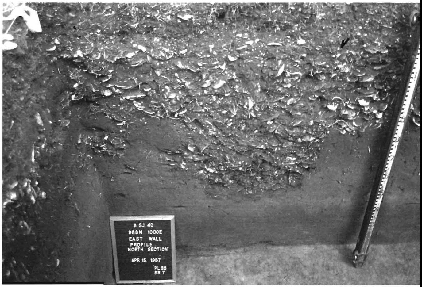
The earthwork walls stood about eight feet tall, faced on the outer side with marsh clay and planted along the top with prickly-pear cactus. A shallow moat surrounded the fort on three sides — the 1759 parish report gives it as three feet wide and two feet deep, and the excavation measured it at about two meters wide and two and a half feet deep — also planted with cactus. Although it has long since been filled in, its configuration is clearly evident in profile, as is the layer of clay along its inner slope.(10)
The fort’s parish priest, Father Juan Joseph de Solana, described it in 1759. The fort, he wrote, was “situated on the banks of the River which runs to the north, and at a distance of 3/4 of a league from the presidio.” The part that faced the river, he noted, “has no protection or defense whatsoever and is formed by two small bastions which look landward,” on which were mounted two four-pound cannons and six swivel guns. The face of the wall “appears to be of thirty tree-trunks,” and the earthwork embankment was “covered with thorns.” He recorded that only twelve of the free Black men were fit for garrison duty, divided into two watches of six, who by day went to their work and were replaced by four soldiers, two artillerymen, and one corporal; the rest of the free Black residents lived in the city. The buildings within the fort were “some huts or shacks of palm thatch,” and the chapel was ten meters long and six wide, its walls of wood then under construction.(11)
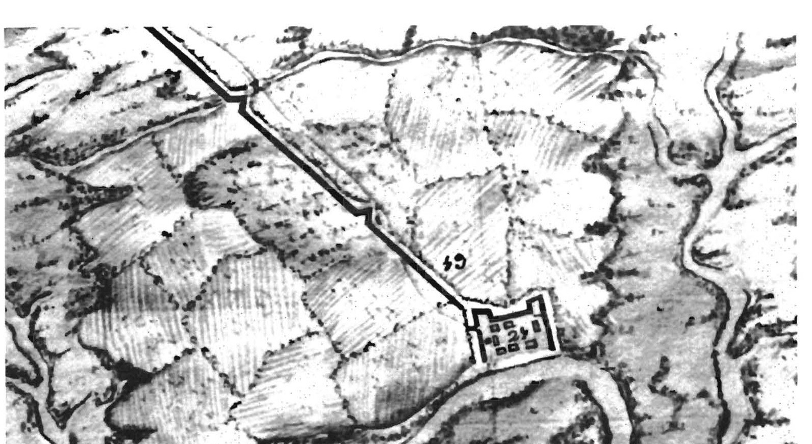
The fort’s armament was modest: two cannons and four iron half-pound stonethrowers as artillery, in addition to twenty-four muskets for the soldiers. A map by Pablo Castello shows seven structures within the fort, and excavations recovered the posts of a watchtower with posts some 45 centimeters in diameter, as well as a smaller oval or circular wood-and-thatch structure roughly twelve feet in diameter that may have been residential.(12)
The 1762 defense line
In 1762 the men of Mose added an earthwork and moat extending from the fort west to the San Sebastian River, a distance of about two miles. Built of earth and yucca — the same prickly-pear cactus that lined the moat around the fort — the line contained several triangular bastions along its length and made Mose the anchor of the city’s outermost defense. The Defense Lines page covers this work and the other two lines that protected St. Augustine in full.(13)
What the archaeology found
Deagan’s team located and verified the 1752 fort and the defense line extending outward from it. The site is on a small marsh island north of the Castillo de San Marcos. The excavations uncovered portions of the moat (in three places), part of the earthwork curtain, and the posts from large and small interior wood-post structures. Some 112 discrete deposits dating to the Mose occupation were recovered, including sheet-deposit levels, post molds, the moat fill, pits, and other features.(14)
The artifacts were those of military and domestic life: gunflints, bullets flattened by impact, metal buckles and buttons, thimbles, nails, ceramics, and glass bottles, along with food remains such as burned seeds and bone. The clay layer that faced the earthen embankment is clearly visible in the wall profile, confirming the documentary accounts of a clay-faced fort.(15)
After 1763
Mose was abandoned by the Spanish in 1763, when Florida was ceded to England; all of the residents went to Cuba with the other inhabitants of St. Augustine. The fort itself, owing to its strategic position, was occupied intermittently by military forces until 1812 — but never again was it a Black community.(16)
In 1812, during the Patriot War, the First Regiment of United States Riflemen under Lieutenant Colonel Thomas A. Smith occupied Fort Moosa on April 12. The Spanish set fire to the fort on May 16 to prevent its reoccupation. The Patriot War pages carry the full account, drawn from Smith’s own letters. Today the site is Fort Mose Historic State Park and a National Historic Landmark; nothing remains above ground of the original fort, and a film, visitor center, and museum tell the story.(17)
The 2025 reconstruction
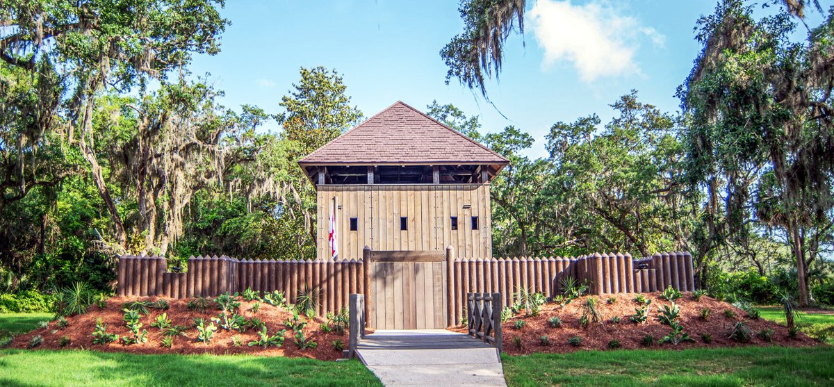
In 2025, Fort Mose Historic State Park opened a full-scale, life-sized reconstruction of the 1738 fort — the first fort, destroyed in 1740. It opened to the public on May 9, 2025. The structure stands about 39 feet tall and three stories high, built with an enforced concrete frame faced to mimic the wood of the original 18th-century structure. It was the work of a partnership among the Florida State Parks Foundation, the Fort Mose Historical Society, and the Florida Park Service, funded by roughly $3 million in grants and donations. Dr. Kathleen Deagan and Dr. Jane Landers, who led the original discovery of the site in the 1980s, guided the design and construction “to ensure historical accuracy.”(18)
The reconstruction is an interpretive structure — “designed to reflect the original 1738 fort” — rather than a literal archaeological replica. It is also not on the actual site: it stands some distance from the location of the second fort, whose site, like the first fort’s, lies in the marsh and is closed to visitors. As Deagan and Landers put it, “the second fort is surrounded by inundated marshlands, and the first fort is underwater.”(19)
Built to modern standards, the reconstruction differs in several respects from the documented 1738 fort. The British report described that fort as “four square with a flanker at each corner, banked with earth, having a ditch without on all sides lined round with prickly royal and had a well and house within, and a look-out.” The reconstruction’s visible form — a tall timber tower within a palisade stockade, with a planted cactus berm rather than a ditch — evokes the period, but it is not a point-for-point match to that account: it is a wood-and-concrete structure rather than an earth-berm work, it shows no moat on all sides, and it does not display the corner flankers the British recorded.(20)
The park and its partners have presented the fort as a monument and an interpretive aid — a way to make the story of America’s first legally sanctioned free Black community physically tangible — not as a strict archaeological restoration. For a historical record it is worth keeping the distinction in view: the reconstruction is a modern interpretation, and the documented account of the 1738 fort remains the description above.(21)
References
- 1. Kathleen Deagan and Jane Landers, “Fort Mosé: Earliest Free African-American Town in the United States” (1990) (the two forts on the same marsh island, the tidal creek). (return)
- 2. Deagan and Landers, op. cit. (the 1987–88 excavations, the thermal imagery, the first fort now underwater, the second fort verified). (return)
- 3. Florida Museum of Natural History education packet (1991), Kathy A. Deagan, “Fort Mose: America’s First Free Black Community” (the first fort: square earth-berm, flanker at each corner, cactus moat, house, lookout, well; stone and wood). (return)
- 4. British report, quoted in Deagan and Landers (1990) (the first fort “four square with a flanker at each corner”), South Carolina Archives (1954), p. 25. (return)
- 5. Florida Museum of Natural History education packet (1991) (the first fort’s layout, similar to other Spanish Florida forts). (return)
- 6. Verne E. Chatelain, The Defenses of Spanish Florida 1565–1763 (1941) (the fort built in 1738 or 1739); Deagan and Landers (1990) (the thirty-eight men). (return)
- 7. The St. Augustine Expedition of 1740: A Report to the South Carolina General Assembly (1954) (the evacuation, Palmer’s occupation, the gates burnt and three breaches made); Florida Museum education packet (1991). (return)
- 8. Deagan and Landers (1990) (the twelve-year abandonment, the 1752 reestablishment under García de Solís, the second fort “very close to the location of the first, but larger and of a different configuration”). (return)
- 9. Florida Museum of Natural History education packet (1991) (the 1752 fort: a quarter league farther north, three-sided, open on the river, bastions at the northwest and southwest corners, clay-faced earth walls). (return)
- 10. Deagan and Landers (1990) (the eight-foot walls, the marsh clay, the cactus, the moat two meters wide and two and a half feet deep, the clay layer in profile); Father Juan Joseph de Solana, report (1759) (the moat three feet wide and two feet deep). (return)
- 11. Father Juan Joseph de Solana, report to Bishop Pedro Agustin Morel de Sánchez, April 22, 1759 (the fort’s position, the two bastions, the cannons and swivel guns, the thirty tree-trunks, the thorns, the garrison, the thatched huts, the chapel). (return)
- 12. Florida Museum of Natural History education packet (1991) (the two cannons, four stonethrowers, twenty-four muskets; the Castello map, seven structures); Deagan and Landers (1990) (the watchtower posts, the twelve-foot structure). (return)
- 13. Deagan and Landers (1990) (the 1762 earthwork and moat to the San Sebastian River); Florida Museum education packet (1991). (return)
- 14. Deagan and Landers (1990) (the moat in three places, the earthwork curtain, the interior structures, the 112 deposits). (return)
- 15. Deagan and Landers (1990) (the artifacts: gunflints, flattened bullets, buckles, buttons, thimbles, nails, ceramics, bottles, burned seeds, bone); Florida Museum education packet (1991). (return)
- 16. Florida Museum of Natural History education packet (1991) (the 1763 abandonment, the occupation until 1812). (return)
- 17. T. Frederick Davis, “United States Troops in Spanish East Florida, 1812–1813,” The Florida Historical Quarterly (1930), Part 1 (the 1812 occupation and burning); Fort Mose Historic State Park. (return)
- 18. Florida State Parks Foundation, “Viva Mose! Fort Mose Historic State Park To Celebrate First Anniversary of Fort Reconstruction” (May 4, 2026) (the 2025 reconstruction of the 1738 fort, opened May 9, 2025, 39 ft, three stories, the partnership, Deagan and Landers guiding the design); Florida’s Historic Coast, “Fort Mose Unveils Reconstructed Fort” (2025) (the enforced concrete frame faced to mimic the wood). (return)
- 19. Deagan and Landers (1990) (“the second fort is surrounded by inundated marshlands, and the first fort is underwater”); Fort Mose Historic State Park (the reconstruction’s placement some distance from the second fort’s site, which is closed to visitors). (return)
- 20. British report, quoted in Deagan and Landers (1990) (the 1738 fort “four square with a flanker at each corner, banked with earth…”); the 2025 reconstruction as documented by the park and Florida’s Historic Coast (2025). (return)
- 21. Florida State Parks Foundation, op. cit. (the fort as a monument and interpretive aid); Discover Fort Mose, “Rebuilding History: The Long-Awaited Reconstruction of the 1738 Fort Mose” (Nov. 2024) (the “where’s the fort?” context, the roughly $3 million). (return)
See also: Fort Mose and Siege of St. Augustine (1740) and Patriot War (Florida) on Wikipedia.